|
A few bits of trivia, which I hope you will find interesting, and some of my "ramblings". A coffee bean is a hugely complex source of many different compounds: it contains around 1 to 2% of caffeine, along with volatile oils ( the aroma ) tannin, and traces of theobromine, and theophylline: traces of many other compounds, most of which are beneficial to people. Its effects are as a stimulant to the central nervous system, and a diuretic: it also has benefits in cases of narcotic poisoning: excessive coffee intake can cause insomnia, muscle tremors, restlessness, and upset the normal heart rhythm. The fruit of the coffee plant ( the fleshy skin around the coffee beans ) is weight for weight, the richest source of polyphenols ( dietary antioxidants ) so far discovered in the plant kingdom.I have been drying and processing them, and taking a couple of teaspoon full's ( prepared as a "tea" ) each day, for about 18 months: with noticeable beneficial effects! The logic or reason, totally escapes me, but the "box" by which coffee cherries are measured in Jamaica, a wooden box 19 x 14 x 10 inches, is the same measurement as the international standard box for a beehive!! Air temperature drops approx 6.5C per 1,000 metres ( about 12F over 3,300 feet ) which makes my plantation ( 3,500 feet ) about 12 to 13F, cooler than the coast. Which gives these Mountains, the wonderful "cool" climate, when compared to the heat and humidity, along the coast: all the advantages of living in the tropics, without the excessive heat, and humidity. These slightly lower temperatures have a secondary beneficial effect, severely limiting the numbers of mosquitoes, and other "nasty" insects. At 3,500 feet air pressure is reduced by about 16%, which means that water boils up here, a few degrees lower than at sea level; instead of 212F, water boils at between 202 and 203F ( as accurately as I can read the thermometer ) or about a 5% lower temperature. This lower air pressure, is only noticeable when my ears "pop" during the drive to and from Kingston. The car also notices the difference, running much better in Kingston, than it does up here: despite all the tuning and adjustments I make to it. The thinner air, with less ability to "hold" pollutants, and the almost total absence of "light pollution", gives us a superb view of the starry, night sky, from the plantation. Another preposterous claim I found on the internet, is that at higher elevations, the proportion of Oxygen in the air is greater, which helps the coffee grow: the ONLY variation in the composition of the atmosphere, below 5 miles, is the amount of water vapour ( humidity ) in the air: the proportions of the main gasses in the air, remain almost constant, regardless of elevation. There are obviously minor variations, very localised, for example, man made pollution, or just downwind of a major forest fire!! Below about 10 miles, the atmosphere is so "active", that the gasses are almost totally mixed to a consistent, and relatively constant, composition; Hydrogen and Helium, being the exceptions ( but they form a very small percentage of the atmosphere ) as they are very much lighter than the other gasses. At the higher levels of the atmosphere, sunlight interacting with oxygen, produces the ozone layer, and other compounds, which do not occur at lower levels. Half the mass of the atmosphere is below 18,000 feet ( just over 3 miles ) and at 5 miles ( a bit short of the peak of Everest ) the air pressure is about one third of that at sea level, and contains insufficient oxygen to sustain ( active! ) human life. Virtually all "weather" is located in the lower parts of the atmosphere, water can only exist as a liquid, below about 18,000 feet, above that height, it is frozen to ice. Due to the spin of the Earth, the atmosphere is thinner at the poles, than at the equator; and "weather" is limited to a height of about 4 miles at the poles, and about 12 miles, at the equator: a hurricane can reach over 10 miles in height.
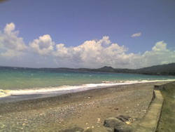
Sunbeams, just after the sun set below the mountains. Up here, at 3,500 feet, a gust of wind from a hurricane, with the air being 16% "thinner", contains less kinetic energy, than the same gust, at sea level, and ( should!! at least in theory ) have a lower potential for causing damage. The maths are way beyond me; but the formula for calculating the kinetic energy of the winds, involves ( amongst other things ) the density of the air, the friction from what ever the wind is blowing over, and the cube of the wind speed: a small increase in wind speed, creates a large increase in the kinetic energy and potential damage from the winds. A 150mph gust of wind ( a category 5 hurricane ) contains over 100 times the amount of kinetic energy, found in a 75mph ( category 1 hurricane ) gust of wind. A hurricane requires a "catalyst" before it can form; usually in the form of thunder storms which form over Africa, and drift across the Atlantic ocean: many of the worst hurricanes have their origins in the Cape Verde, area: when the thunder storms, interact with the Islands, and intensify the storms, which can then develop into hurricanes. Hurricanes can only form, by feeding on warm tropical waters, and when the sea temperature falls below, 26C ( about 80F ) there is insufficient heat energy in the water, for a storm to develop. If there are two hurricanes, too close together, the first one extracts all the energy from the warm waters, and the following storm often "starves", and fades out. The winds, and the waves that come ashore along with the storm surge, also have the effect of stirring-up the surface waters, and mixing them with the cooler water, lower down, reducing the sea water surface temperature, even further. In the "dry" season; vast amounts of dust are lifted from the Sahara desert by the winds, which blow the dust westwards, across the Atlantic to the Caribbean area: this dust, and the air holding it, are very dry, and most effective in preventing hurricane formation, by "sucking" the moisture from any potential storm system.
A perfect tropical "blue" sky, with the morning cumulus clouds, starting to form: along the north coast. In the Caribbean area, our weather falls ( very roughly, and in a very generalised way ) into 2 parts: in the summer the prevailing winds ( the Trade winds ) blow from Africa, westwards towards the Caribbean, before turning northwards, and roughly following the Gulf stream, towards Europe. In the winter, the prevailing winds ( along with some cold fronts ) come down from continental North America, from the North west. Storms and hurricanes always spin anti-clockwise in the northern hemisphere ( and clockwise in the Southern hemisphere ) due to the Coriollis effect: which is at its most intense, between 10 and 15 degrees North or South of the equator, it has less effect as one moves towards the poles, and is so weak at the equator, that hurricanes almost never, form in that area. Without the spinning motion, a storm remains just an area of bad weather, and only very rarely, can it develop the storm/hurricane force winds. Due to the spin of the hurricane, and its forward motion; the worst of the winds and rains are almost always ( in the Caribbean area ) on the northern part of the leading edge of the system, where the forward speed of the system is added to the measured wind speed; the southern and trailing edge of the system have slightly ( deducting the forward speed of the system ) lesser wind speeds. We would get more damage, and stronger winds if the storm tracks to the south of the Island, than if it passes to our north. The two late storms that we had in the Caribbean, in 2010, formed, as apparently innocuous thunder storms over the warmest patches of water in the Southern Atlantic: then entered the area of the Caribbean that retained the highest sea temperatures, the areas along the Southern part of the Caribbean sea, abutting the coast of South America: Venezuela and Colombia, and into Central America, around Panama and Nicaragua. Forming in to storms, very quickly, and so close to us, that without the ability to "track" them as they traverse the Atlantic ocean: we had very little warning of their possible, arrival! At any one time, a small hurricane is extracting energy from the warm sea waters at around 400 times the total energy generating capacity, of every country in the world, combined. 99.75% of that energy is used by the storm to maintain its vertical components, and the remaining 0.25% is the energy used to power the winds. NOW: if I could only find a way to cheaply and easily extract that energy from a urricane......................!!!! When you read about "storm surges" from a hurricane: the figure given is the rise in sea level caused by the storm, and does not include the daily tides, or the wave height, on top of the storm surge. Recently the Bahamas were hit by a hurricane, and a 30 foot storm surge was predicted: that would be 30 feet above the tide level, and with 20 foot storm waves on top of that: the water reaching 50 feet above normal ( 50 feet is around the height of the windows on the 6th floor of a modern building! ).
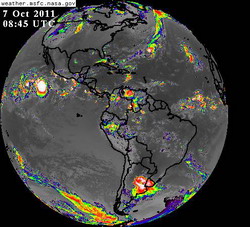
A "snapshot" of half the worlds' weather: over in the Pacific, off the coast of Mexico, is hurricane Irwin. To the east of Florida/Georgia is hurricane Philippe, and you can clearly see the "line" of bad weather stretching from Philippe, north-westwards, towards Europe; roughly following the warm waters of the gulf Stream. Between Africa, and South America there is an area of thunderstorms ( as yet, just bad weather, and it has not achieved sufficient wind speeds, ( 39mph, or more ) to get a name ), this is the area we are watching, at the moment, as it might develop into a hurricane, but it is currently further south than the "usual" area where the storms develop. Sitting over the southern tip of Florida, is an area of thunderstorms, and a LOT of rain, some of the computer models are predicting that this area might develop into a tropical storm, as the water in the area is very warm at the moment. Just south of the Mona passage ( between Puerto Rico, and Hispaniola ) is a "tropical wave", an area of disorganised thunder storms and rain, which should reach Jamaica, in a couple of days, hopefully, as nothing more than some rain! For early October, only just after the "peak" of the hurricane season, the tropical part of the weather map is surprisingly "quiet"! Almost exactly a month ago, the same picture would have shown 6 named storms, 3 of which were hurricanes, just in the Atlantic: between Africa, and the Caribbean/Gulf of Mexico, areas, as well as a couple of "stormy" areas near the African coast. Until next time, and how we process the coffee, here, on my plantation. Robin Plough, friend of www.coffee4dummies.com For questions about JBM, mail to: Этот e-mail адрес защищен от спам-ботов, для его просмотра у Вас должен быть включен Javascript |
Coffee Trivia and other ramblings: part 1
Coffee Trivia and other ramblings: part 1